Tropical Cyclone made landfall over the weekend of May 3 and 4 and killed nearly 4,000 people, according to Reuters news service. Thousands more were reported missing. Cyclone Nargis was a Category three storm on the Saffir-Simpson scale of hurricane strength, packing sustained winds of 120 mph when it made landfall.
In the former capital city of Yangon, sturdy buildings suffered damage where roofs are reported to have town off by Nargis' strong winds. The damage in Yangon suggests that the shanty towns outside the city have likely suffered severe damage.
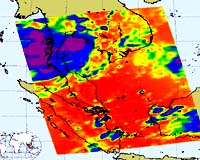
This infrared image of Cyclone Nargis was created on May 4 at 6:29 UTC (2:30 a.m. EDT) by data from the Atmospheric Infrared Sounder (AIRS), an instrument that flies aboard NASA's Aqua satellite.
This AIRS image shows the temperature of the cloud tops or the surface of the Earth in cloud-free regions. The lowest temperatures (in purple) are associated with high, cold cloud tops that make up the top of Nargis (shown as the circular purple area on this satellite image) located over Myanmar.
The infrared signal of the AIRS instrument does not penetrate through clouds. Where there are no clouds the AIRS instrument reads the infrared signal from the surface of the Earth, revealing warmer temperatures (red).
Cyclone Sidr was the last major storm to hit Asia. In November 2007, Sidr killed 3,300 people in Bangladesh.
