A California-headquartered company has been given the go-ahead to commercially operate its unmanned aerial system for a variety of industries.
Trimble, which provides aerial images for 2D and 3D deliverables — such as orthomosaic images, three-dimensional point clouds and contour maps — said permission came through an exemption from the Federal Aviation Administration.
The FAA is allowed to grant exemptions to temporary restrictions on the use of commercial UAVs to "provide a pathway for civil operators who desire safe and legal entry" into the U.S. National Airspace System pending adoption of permanent rules. The agency on Wednesday gave exemptions to four companies.
"We are pleased to be among the first companies to receive an exemption from the FAA authorizing commercial operation of UAS," said Erik Arvesen, vice president of Trimble's Geospatial Division. "This decision reflects Trimble's efforts to responsibly operate its UAS business in the U.S. while the FAA addresses air safety issues in opening the NAS for commercial UAS operations on a broader scale.
"Trimble will continue its efforts to support the FAA's decision-making process and to provide opportunities for our customers to safely use the UX5 to capture accurate geospatial data for a wide range of applications such as surveying, oil & gas, mining, construction and many more."
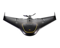
The Trimble UX5 is an electric-powered fixed-wing UAS. It has a weight of just 5.5 pounds, a wingspan of 34.9 inches, a flight endurance of 50 minutes, and a range of 37 miles. The company said that uses Trimble Business Center Aerial Photogrammetry software and can collect large amounts of data, often faster than traditional surveying or mapping technologies.
