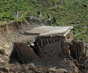
Thirteen people were killed, dozens injured and scores of mud-brick homes were flattened when a powerful earthquake struck eastern Afghanistan on Wednesday, officials said.
The Red Crescent in the worst-hit province of Nangarhar said 12 people were killed there, while one person was confirmed dead in neighbouring Kunar province.
"The number of dead is expected to rise as the search operation is still ongoing," said Nangarhar Red Crescent chief Nagyalay Yusufzai.
He said more than 60 people were hurt in the quake, which sent people rushing from their homes and was felt in the Afghan capital Kabul and in Islamabad in neighbouring Pakistan.
The quake, measured at a magnitude of 5.6 by the US Geological Survey, struck at 0925 GMT at a depth of 62 kilometres (39 miles).
Its epicentre was 24 kilometres northwest of the Nangarhar provincial capital Jalalabad, near the Pakistani border, the USGS said.
Nangarhar government spokesman Ahmad Zia Abdulzai gave a different figure of nine confirmed dead in his province and said more than 100 were injured.
"There has been widespread damage in some affected villages since most of the houses there are mud-built," he told AFP.
One person was killed and one injured in Kunar and many homes were destroyed, said its spokesman Wasefullah Wasef.
In Kama district outside Jalalabad, people ran from their homes in panic when the tremor was felt, a witness said, describing it as "very powerful".
In a separate natural disaster, flash floods Tuesday in the northern province of Balkh killed at least 11 people and left three missing, said Munir Ahmad Farhad, a provincial government spokesman.
"The floods have also damaged close to a thousand homes as well as hundreds of hectares of farmland," the spokesman said Wednesday.
"The badly affected areas are impoverished villages where most of the homes are mud-built and can be easily damaged when floods come. We are worried as it is raining again now."
Afghanistan is frequently hit by earthquakes, especially in the Hindu Kush mountain range which lies near the juncture of the Eurasian and Indian tectonic plates.
In June 2012 two quakes in the area triggered landslides that killed at least 75 villagers.
Wednesday's tremors came a week after a 7.8-magnitude earthquake centred in Iran affected thousands of people in remote southeastern Pakistan and killed 41 people.
Pakistani victims have staged angry protests, accusing the government of failing to provide adequate relief after hundreds of homes were destroyed or damaged.
Strong quake shakes Papua New Guinea: USGS
Sydney (AFP) April 24, 2013 –
A 6.4-magnitude earthquake struck Papua New Guinea on Wednesday, the US Geological Survey said, but no tsunami warning was issued and no damage was immediately reported
The strong quake hit at 09:14 am (2314 GMT Tuesday), 31 kilometres (19 miles) north of Rabaul in the the Pacific nation's east, the USGS said. It was 18 kilometres (11 miles) deep.
Rabaul was the scene of destruction in 1994 when an erupting volcano caused a large number of buildings in the town to collapse, but seismologists said it was unlikely to have suffered any major damage this time.
"It would certainly have given the area a good shake but Rabaul is on the edge of our damage radius," seismologist John Bathgate from Geoscience Australia told AFP.
"There's potential for some damage, but expect it to be very minimal.
"Damage would be more likely in coastal areas of New Ireland," he said, with the quake measured by Geoscience Australia as only around eight kilometres off the coast.
"There was potential for a localised tsunami but it would have passed by now and we have had no reports about one."
Bathgate added: "It's not unusual for the area to experience this type of quakes, or even larger."
Quakes of such magnitude are common in PNG, which sits on the so-called Pacific "Ring of Fire", a hotspot for seismic activity due to friction between tectonic plates.
Last week, a 6.8-magnitude earthquake rocked the country's north but no major damage was reported.
