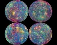
Scientists with the European Space Agency have rendered the dull, gray world of Mercury in bright colors as part of a new mapping effort in preparation for next year's BepiColombo mission launch.
Using data collected by NASA's Messenger mission between 2010 and 2015, scientists plotted a color-coded map of the Victoria Quadrangle, a crater-filled region in Mercury's northern hemisphere.
Researchers used colors to distinguish different types of craters and geological features. Crater characteristics — like levels of degradation — helped scientists estimate the density and age of the surrounding surface. categorize
The entirety of the Victoria Quadrangle features 1,789 craters wider than three miles. In the image released this week by ESA, 867 craters are showcased — 268 in the newly mapped section are wider than 12 miles.
Scientists detailed their plotting project in the Journal of Maps.
The maps developed by ESA researchers will be used to inform the BepiColombo mission, scheduled to launch next year. The mission is a joint effort between ESA and the Japanese Aerospace Exploration Agency.
The mission will feature a pair of probes, programmed to study Mercury. The duo will follow up on geologic features first identified by Messenger, as well as measure the innermost planet's magnetic field, magnetosphere and interior structure.
Small collisions make big impact on Mercury's thin atmosphere
Mercury, our smallest planetary neighbor, has very little to call an atmosphere, but it does have a strange weather pattern: morning micro-meteor showers. Recent modeling along with previously published results from NASA's MESSENGER spacecraft – short for Mercury Surface, Space Environment, Geochemistry and Ranging, a mission that observed Mercury from 2011 to 2015 – has shed new light on how ce … read more
