Cyclone Ita rolled out into the Coral Sea on Monday leaving thousands of homes without power and floods down Australia's Barrier Reef coast, officials said, as danger warnings were lifted.
Downgraded from a category four to a category one storm after making landfall late Friday, Ita swept off the coast with gales and torrential rain trailing in its wake.
Electricity was slowly being restored to some 16,000 homes that were cut off while floods closed local roads, emergency officials said. No deaths or major destruction were reported.
The Bureau of Meteorology lifted the last cyclone warning south of Mackay and north of Rockhampton on Monday morning and Ita was expected to be further downgraded to a low pressure system during the day.
"Tropical Cyclone Ita is expected to maintain a southeast track as it moves offshore away from the Queensland coast," the latest bulletin said.
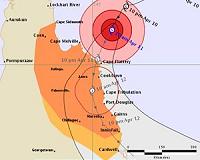
Further north in Cooktown, which bore the brunt of the storm, water was rationed to drinking and "minimal" sanitation only, with severe shortages due to storm damage.
Queensland premier Campbell Newman inspected the damage in Cooktown on Sunday, where four buildings were destroyed and another 50 were damaged by the storm. Banana plantations in the region were flattened.
Newman said rain had damaged up to 20 homes and another 30 had been cut off in the tourist town of Port Douglas by flooding.
He appointed a disaster recovery coordinator for three months to oversee the clean-up.
Tropical cyclones are common in Australia's northeast and northwest.
Cyclone batters Australia's Great Barrier Reef coast
Sydney (AFP) April 12, 2014 –
A tropical cyclone battered Australia's Barrier Reef coast Saturday, knocking out power and phone lines for thousands of people and threatening floods, despite weakening as it headed south towards major tourist resorts.
Tens of thousands of people hunkered down overnight as strong gales and heavy rains lashed the far north, but no casualties or major destruction was reported as cyclone Ita was downgraded to a category one storm.
Ita crossed the coast near Cape Flattery late Friday as a category four storm packing winds up to 230 kilometres per hour (140 miles per hour), tearing off roofs and uprooting trees.
Queensland state Premier Campbell Newman said several thousand people across the far north had lost electricity and warned that cyclone Ita "continues to be a threat".
"I am greatly relieved at this time that we have no reports of either death or injury," he told a press conference, while urging people to stay indoors or in shelters "until this is properly over".
As authorities started the clean up in the wake of the storm, cyclone warnings remained in force from Cooktown to the bigger Barrier Reef resorts of Port Douglas and Cairns, 1,700 kilometres (1,060 miles) north of Brisbane.
Roofs were ripped off two homes and a pub in the coastal resort of Cooktown where several trees were uprooted during the night, officials said.
Large parts of the 1,000 strong Aboriginal community of Hope Vale and Cooktown, population 2,400, had lost power.
The storm was downgraded from the strongest category five before it made landfall Friday night.
Before midday (0200 GMT) the Bureau of Meteorology said Ita had weakened to a category one.
By 3:00 pm it was 85 kilometres northwest of Cairns and moving southeasterly at seven kilometres an hour.
– Still packing a punch –
Winds gusting up to 120 kilometres per hour were still possible between Cooktown and Port Douglas on Saturday, with gusts up to 100 kph as far south as Cairns and surrounding inland areas, the bureau said.
It also warned of heavy rainfall possibly leading to flash flooding and coastal inundation from a storm surge.
Tropical storms are common in northeastern Australia.
Before weakening offshore, Ita had threatened to be stronger but not as widespread as the monster Cyclone Yasi system that tore through the region just over three years ago, ripping homes from their foundations and devastating crops.
Cooktown Mayor Peter Scott told Australian Associated Press he felt relieved as he had feared waking to widespread devastation.
"There's a lot of vegetation on the road and we've unfortunately seen some buildings damaged," he said.
"But there hasn't been a lot of structural damage."
Local resident Diana Spiker spent the morning walking her dog and had also expected far worse.
"They were talking about a category five at one stage so I thought there would have been a lot more damage," she said.
The bureau's Ken Kato said Ita could be further downgraded to a tropical low.
He expected the cyclone to head out "into the Coral Sea somewhere off the north tropical coast" on Sunday or Monday.
"But it's still packing a fair punch," Mr Kato added.
Meanwhile, the bureau issued a severe weather warning with strong winds and large waves for the Sydney region.
Gusts peaking at 100 kph were predicted to hit the southeastern coastal areas Saturday as a low pressure system developing off New South Wales deepens before moving inland towards the Hunter Valley in the afternoon.
