After the earthquake of 8.1-magnitude in Nepal, China Meteorological Administration (CMA) connected with Nepal Department of Hydrology and Meteorology(DHM) as soon as possible to learn about the operational conditions of CMACast and MICAPS system.
Due to earthquake, the internet of Nepal has broken off. Without relying on local internet, CMACast and MICAPS became the main weather forecast platform within 24 hours after earth quake which provided powerful supports for earthquake relief and also showed the systems' emergency capabilities.
It's reported that CMA donated CMACast and MICAPS systems for 19 Asia-Pacific countries including Nepal.
CMACast is the updated satellite data broadcast system of CMA based on DVB-S2 technology with both file and multimedia transmission capability. It is a major component of CMA national and international data dissemination network. CMACast is also a major component of IGDDS and GEONETCast.
Meteorological Information Comprehensive Analysis and Process System is short for "MICAPS", which is a man-human interaction system supporting weather forecast.
Via searching various meteorological data, it displays graphics of meteorological data, edits and processes various meteorological graphics, and provides a medium-term, short-term, nowcasting analysis platform for meteorological forecast and business staff, meanwhile, provides abundant second construction interface, and constructs secondly on the basis of original version according to users' needs.
CMA has dispatched expert teams to Nepal DHM to carry out technical aid and training on CMACast, MICAPS, and GMSOFT in 2012, 2013 and 2015.
Chinese satellites monitoring Nepal quake zone
Beijing, April 28 (Xinhua) – Chinese satellites are monitoring areas affected by Nepal's quake while providing hi-resolution images for relief effort, the State Administration of Science, Technology and Industry for National Defence (SASTIND) said Tuesday.
Four land observation and mapping satellites have been targeting the epicenter of the quake, Nepal's capital Kathmandu and its northern area as well as two affected counties in southwest China's Tibet Autonomous Region, the administration said in a statement.
These satellites have offered 209 sets of images to ten departments including China Earthquake Administration and the ministries of civil affairs, science, land and resources.
Meanwhile, the SASTIND has been processing hi-res image archives of the quake zone in the past as references for image analysis.
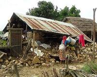
The 8.1-magnitude earthquake struck Nepal at midday on Saturday, followed by strong aftershocks. More than 4,300 people in Nepal and at least 25 in Tibet were killed in the disaster.
The SASTIND vowed to keep close track of the situation and share satellite images with quake-affected areas.
Nepal in round-a-clock update with China's satellite images and forecast
Kathmandu, April 28 (Xinhua) – Nepal has been in regular update with latest satellite images and weather forecast provided by Chinese Meteorological Administration (CMA), Meteorological Forecasting Division of Nepal said on Tuesday morning.
Nepal has been checking the FY2E image series and the generated forecast of South Asia region round the clock through its receiver in Kathmandu, at a time when the Himalayan nation has been getting aftershocks after a major earthquake on Saturday.
"We have direct access to the image and forecast of CMA and we are in regular updates, " Subash Rimal, weather expert at Meteorological Forecasting Division told Xinhua over phone.
According to the Meteorological Forecasting Division, a cloud patch has entered to Nepal on Tuesday morning.
"A cloud patch has moved from Uttarkhand side of India to Nepal which can cause partial rainfall in the capital and other parts of nation later in the day," Rimal said.
