A new image from the European Space Agency's Copernicus Sentinel-2A satellite showcases the extreme aridity of India's Thar Desert.
Geologic and archaeological analysis suggests the region, which encompasses more than 123,000 square miles in India and Pakistan, was once green and lush. Centuries of farms have depleted water resources and taxed the soil, slowly drying out the land.
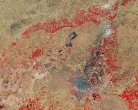
Today, the region is dotted by dunes. The false-color image features the city of Bikaner. Sand dunes and irrigation-supported farms surround the city.
Life is tough for farmers in the region. Desertification spreads as dry desert sands are blown by winds onto more fertile nearby acreage, degrading the soil.
Though irrigation has been used to further develop agricultural lands, India's government has also spearheaded several irrigated planting projects in order to restore stave off desertification and return some of the acreage to its previous vegetated state.
Satellites forewarn of locust plagues
Satellites are helping to predict favourable conditions for desert locusts to swarm, which poses a threat to agricultural production and, subsequently, livelihoods and food security.
Desert locusts are a type of grasshopper found primarily in the Sahara, across the Arabian Peninsula and into India. The insect is usually harmless, but when they swarm they can migrate across long distances a … read more
